

Slieve League [Sliabh Liag]
Good walks are even better shared.
G5478 : Donegal: Slieve League Summit Triangulation Pillar
Michael Murtagh Photo source
Overview
Slieve League (Sliabh Liag) is a 596.4 m coastal mountain above Teelin in south-west County Donegal, Ireland. Bunglass is a lower tourist viewpoint; the marked Pilgrim Path ends on an eastern plateau. The actual summit lies farther west beyond a narrow, exposed connecting ridge. Summit outings require experienced mountain walkers, sound navigation and conditions safe enough to cross the ridge again on the return.
Slieve League and its true summit
Slieve League (Sliabh Liag) rises to 596.4 m above the coast of south-west County Donegal. The name means “mountain of the flagstones”. Bunglass is the tourist viewing area below the mountain. The signed Pilgrim Path reaches the church and eastern plateau; reaching that plateau does not mean reaching the main summit.
DoBIH records the highest feature as raised ground 50 m north of the trig point, at G 54346 78387. It also notes a small cairn 70 m east-southeast of the trig, at G 54411 78357, which may be equally high. The separate SE Top is 576.7 m. Keep these features distinct when planning a summit visit.
Routes and full returns
Pilgrim Path to the main summit and back
Start at the signed Shanbally walkers’ parking off the Carrick–Teelin road. Follow the track past Croleavy Lough and the waterfall, then climb the rough upper path to the church plateau. The summit extension continues west over bog and rock and across a narrow exposed connecting ridge to the trig area and raised summit ground. Return across the same ridge and descend the Pilgrim Path to the original parking. Pat’s Donegal Walking gives this full outing as 10 km, 3.5–4 hours and about 550 m ascent. These are that guide’s figures, not the official marked-trail figures.
Bunglass to the main summit and back
From the viewing area, climb the constructed cliff path and continue along the rough ridge past the eastern top, then west across the exposed connecting ridge to the main summit. Retrace the whole route to Bunglass. Lower-parking approaches or a confirmed shuttle return are additional logistics. The name One Man’s Pass is applied to different narrow sections. Avoiding an earlier rocky crest does not remove the narrow ridge between the eastern approach and the true summit. Both summit itineraries require that ridge to be crossed again on return.
Pilgrim Path plateau return
Follow the signed inland approach from Shanbally to the church remains and eastern cliff plateau, stay back from the cliff edge, then retrace the same path to the car park. Sport Ireland and Discover Ireland list 3.2 km each way and 425 m ascent; Sport Ireland expressly gives 2–2.5 hours for there-and-back and grades it strenuous. Its older downloadable card instead gives 7 km return, 3–4 hours and 438 m ascent. Keep those source versions separate. Neither set includes the exposed western summit extension. Dogs are not allowed on the marked trail.
Ranger Station viewpoint return
Walk uphill on the signed pedestrian approach beside the road from the Ranger Station to Bunglass, about 2 km outward according to Discover Ireland, and return the same way. Stay in the designated viewing area and follow barriers or diversions. This outing does not reach the main summit or require continuing along the upper ridge.
Safety
The main-summit ridge has steep drops on both sides. Experienced mountain walkers need a head for heights and conditions suitable for the return crossing, not merely the outward one. Do not attempt the ridge in strong wind, mist or slippery conditions. Loose stone, wet rock and boggy ground require care elsewhere; cliffs are also close to the Pilgrim Path plateau. Carry mountain clothing, food, water and navigation equipment. Turn back before committing if the group or weather is unsuitable. In a mountain emergency call 999 or 112 and ask for Mountain Rescue.
Access, transport and facilities
The inland Pilgrim Path parking is separate from the Bunglass road-access system. Park considerately, close gates and keep farm access clear. The Bunglas Road Visitor Centre advertises free parking; Ranger Station parking is paid and closer to the viewpoint. Upper-car-park vehicle access is seasonally controlled. Follow current local signs and staff instructions.
TFI Local Link 293 serves Carrick on the Donegal Town–Glencolmcille route; confirm the current timetable, any Teelin connection and the last return. Shuttles reach the viewing area, not the summit. Seasons and departure points differ: Sliabh Liag Tours advertises March–October from its Teelin base, while the Bunglas Road visitor-centre FAQ describes a summer and bank-holiday service. Confirm the specific operator and return before relying on either. A Pilgrim Path ascent followed by descent to Bunglass needs a prearranged transfer back to the inland start; it is not automatically a closed walking circuit.
The Bunglas Road Visitor Centre has a café, toilets and interpretation displays. Toilets are also listed at the Ranger Station, but not at the viewing point. Check current opening times and take supplies for the hill. Teelin and Carrick offer further services.
Geology, landscape and heritage
Geological Survey Ireland identifies the cliffs mainly as Dalradian Slieve Tooey Quartzite, with quartzite and gneiss at the base. Younger Lower Carboniferous sandstone and conglomerate outliers survive near the summit. Glacial and periglacial corries were later invaded and trimmed by the sea; the coastal slope is not one uninterrupted vertical wall.
The traditional Pilgrim Path leads to Aodh Mac Bricne’s Church remains on the eastern plateau. In clear conditions the coast, Donegal Bay, Sligo hills and Rathlin O’Birne can be seen from different parts of the mountain. Adjacent summits include Slieve League SE Top, An Cnoc Ramhar and Leahan. Keep to established paths and respect the fragile mountain habitats.
Explore routes near Slieve League [Sliabh Liag]
Walks starting near this hill. Open a route to check its map, distance and full itinerary.
Route planning notes
These notes describe possible approaches. Check a route's map and access information when planning your walk.
Pilgrim Path and main summit return from Shanbally
Start at the signed Pilgrim Path walkers’ parking at Shanbally, reached by the inland lane off the Carrick–Teelin road. Follow the track past Croleavy Lough to the waterfall, then the rough upper path to the church plateau. Continue west across boggy, rocky ground and the narrow exposed connecting ridge to the trig area and the raised summit ground 50 m north of it. Return across the same ridge and descend the Pilgrim Path to the same parking. Pat’s Donegal Walking gives this summit outing as 10 km, 3.5–4 hours and approximately 550 m ascent. This extension goes beyond the marked plateau trail: experienced mountain walkers need a head for heights and safe conditions for both crossings. Turn back before the ridge in wind or poor visibility.
Bunglass to the main summit and back
Begin at Bunglass viewing area, reached by the permitted road approach or a confirmed shuttle. Climb the constructed cliff path and continue on the rough ridge past the eastern top. The main summit lies farther west, beyond a narrow exposed connecting ridge, at raised ground 50 m north of the trig point. Retrace the whole outward route to Bunglass, recrossing the summit ridge and descending the cliff path. Allow separately for the return to lower parking or the booked shuttle. One Man’s Pass is used for different narrow sections; an inland bypass of an earlier rocky crest does not remove the exposure on the ridge to the actual summit. This is a demanding mountain outing for experienced walkers, not a viewpoint stroll or a signed circuit. Avoid wind, mist and slippery conditions.
Pilgrim Path plateau return (does not reach summit)
From the signed Shanbally walkers’ parking, follow the Pilgrim Path track past Croleavy Lough and the waterfall, then the rough ascent to the church remains and eastern cliff plateau. Stop well back from the cliff edge and return by the same path to the same parking. Sport Ireland and Discover Ireland describe 3.2 km each way and 425 m ascent; Sport Ireland gives 2–2.5 hours for the there-and-back outing and grades the trail strenuous. These figures end on the eastern plateau, not at the 596.4 m main summit. Do not continue west onto the exposed summit ridge as part of this route. Dogs are not allowed on this marked trail.
Ranger Station to Bunglass viewpoint and back (no summit)
From the paid Ranger Station parking, take the signed pedestrian approach beside the access road uphill to the Bunglass viewing area. Discover Ireland describes the outward approach as 2 km. Enjoy the cliff views from the designated area, then retrace the same approach to the Ranger Station parking. Keep clear of shuttle vehicles and follow local barriers or diversions. This return stays at the tourist viewpoint and does not ascend to the mountain summit; do not follow the rough upper ridge as an extension of a short viewing visit.
Make a day of it, together
Find someone to share the walk with, or organise a day out along a route you like.
Photo Gallery
View all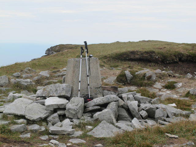 Photo could not load
G5478 : Donegal: Slieve League Summit Triangulation Pillar
Michael Murtagh
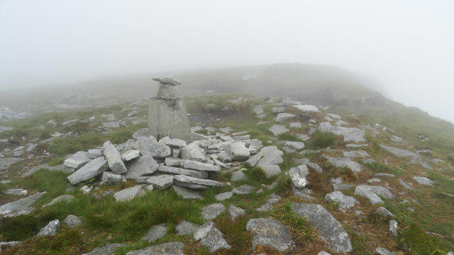 Photo could not load
G5478 : On Slieve League - trig point
Colin Park
Hill facts and local notes
Classifications
Elevation
596m
1,957 ft
Prominence
475m
Coordinates
54.6515, -8.7081
G543783
OS Map
10
At the Summit
DoBIH records raised ground 50 m north of the trig point as the summit, at G 54346 78387. Its observation adds that a small cairn 70 m east-southeast of the trig, at G 54411 78357, may be equally high. The trig pillar is a landmark rather than the recorded highest feature. The 576.7 m SE Top and the Pilgrim Path plateau are separate from this main summit.
Terrain & Geology
The cliffs are formed mainly from Dalradian Slieve Tooey Quartzite, with quartzite and gneiss at their base. Around the summit, younger Lower Carboniferous sandstone and conglomerate survive as outliers above the much older quartzite. Geological Survey Ireland describes glacial and periglacial corries subsequently invaded and trimmed by the sea. The great coastal slope is not one continuous vertical rock face.
Views & Scenery
Clear weather opens views over the Atlantic and Donegal Bay towards the Sligo coast and Ben Bulbin, with Rathlin O’Birne offshore. Bunglass offers the classic view along the cliffs; the main summit and eastern plateau provide different perspectives. Cloud can hide the sea and ridge.
History & Heritage
Name Origin
Sliabh Liag means “mountain of the flagstones”, as recorded by Paul Tempan in Irish Hill and Mountain Names.
Historical Significance
The inland Pilgrim Path follows a traditional pilgrimage route to the remains of Aodh Mac Bricne’s Church on the eastern plateau. The church site and pilgrimage destination are distinct from the higher western summit.
Getting There & Facilities
Parking
Choose parking for the intended route. The inland Pilgrim Path starts at the signed small walkers’ parking at Shanbally, reached by a narrow lane off the Carrick–Teelin road; keep gates and farm access clear. For Bunglass, the Sliabh Liag Visitor Centre on Bunglas Road advertises free parking and the closer Ranger Station has paid parking. The Ranger Station is about 2 km from the viewpoint; the visitor centre is farther away. Vehicle access to the upper viewpoint parking is seasonally controlled, so check the current arrangements and follow staff and signs. Parking at Bunglass or riding a shuttle reaches the viewpoint, not the summit.
Public Transport
TFI Local Link 293 links Donegal Town and Glencolmcille via Carrick; check its current timetable and any Teelin connection. Arrange onward travel and the return separately. Viewpoint shuttles are seasonal: Sliabh Liag Tours advertises March–October, while the Bunglas Road visitor-centre FAQ gives a summer/bank-holiday pattern. Confirm the operator, departure point and last return. Shuttles go to Bunglass viewing area, not the summit.
Nearby Facilities
The Bunglas Road Visitor Centre has a café, toilets and interpretation displays; the Ranger Station also has toilets. The operator lists no toilets at the viewing point. Plan supplies before the mountain walk and check facility opening times. Teelin and Carrick have places to eat and drink.
Safety Information
Known Hazards
- The true-summit routes cross a narrow, exposed ridge with steep drops on both sides and must recross it on the return. A bypass of an earlier rocky crest on the Bunglass approach does not make the summit route exposure-free.
- Strong wind, mist, rain and slippery rock can make the ridge dangerous. Turn back before committing when conditions or the group’s ability are unsuitable; the constructed tourist path is not a maintained path all the way to the summit.
- The Pilgrim Path has loose stone and rough upper ground beside steep cliffs. Keep back from edges, carry a map and compass, and do not depend on cairns alone in cloud. Dogs are not allowed on the marked Pilgrim Path.
- Use established paths, close gates and respect livestock and local access signs. For a mountain emergency call 999 or 112 and ask for Mountain Rescue.
Seasonal Hazards
This Atlantic-facing ridge is highly exposed to wind and rapidly changing visibility. Wet rock and boggy ground demand care; allow enough daylight for the full return, including lower-parking approaches. Check the forecast and current local access notices before setting out.
General Safety Tips
- Check weather conditions before setting out
- Carry appropriate clothing and equipment
- Let someone know your planned route
- Take a map, compass, and GPS device
- Carry emergency supplies: food, water, first aid kit, torch
Hills
Some common questions about the hills answered
Are there group walks up Slieve League [Sliabh Liag]?
Many walkers use Walkmates to join or organise walks with others. You can check for group walks around Slieve League [Sliabh Liag] through the maps
Are there other walkers around Slieve League [Sliabh Liag]?
Activity varies by location and time, but Walkmates lets you see whether others have shared walks or shown interest in this area. Find other people through the walking friends search walking friends for Slieve League [Sliabh Liag] search or of course create your own walk for Slieve League [Sliabh Liag]
Can I organise a walk to Slieve League [Sliabh Liag]?
Yes. If there aren’t any walks listed already, you can create a walk and make it available for others to join.
If you're signed up to Walkmates, you can create a walk to Slieve League [Sliabh Liag].
How do I find a walk up this hill?
There are often multiple ways to walk this hill, depending on experience and route preference. Walkmates helps you explore walks and routes that others have shared.
Can I suggest a new route up Slieve League [Sliabh Liag]?
Yes. You can suggest or create routes to share with others. Walkmates focuses on the social side of walking, so routes are used to help people organise walks and explore areas together, rather than as detailed navigation tools or route libraries.
Other uses really appreciate knowledgeable walkers sharing their routes. Share your favourite route to Slieve League [Sliabh Liag] here
The is an error or something incorrect about this hill. How do I let you know?
We always strive to keep the information on Walkmates as accurate as possible. If you find an error, please let us know through the contact form and we'll aim to correct it as quickly as possible
Community Discussion
Comments
Location
![Slieve League [Sliabh Liag] location map](https://cdn.walkmates.com/hill-maps/hill-sources/20222/54.65153_-8.70805.png)
Grid reference: G543783
View on OpenStreetMapOpens a map in a new tab, centred on the hill.
No comments yet. Be the first.